Westward: Seven Ranges survey changed the country
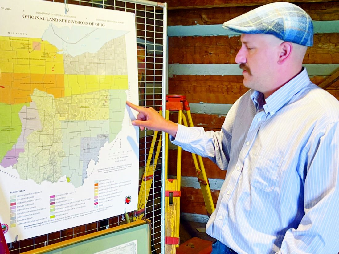
Paul Zuros, executive director of Historic Fort Steuben, points to a map that includes the Seven Ranges of the Northwest Territory that is displayed in the Mike Besch Museum of Surveying. (Photo by Ross Gallabrese)
-

- Paul Zuros, executive director of Historic Fort Steuben, points to a map that includes the Seven Ranges of the Northwest Territory that is displayed in the Mike Besch Museum of Surveying. (Photo by Ross Gallabrese)
-

- This display inside the Mike Besch Museum of Surveying at Historic Fort Steuben depicts what land work looked like in the Northwest Territory — surveyors took their measurements while being protected by a soldier from the First American Regiment. (Photo by Ross Gallabrese)
-
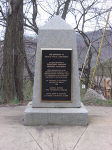
- A small obelisk commemorates the Point of Beginning for the historic survey of the Northwest territory. It sits along Ohio State Route 39 near the Pennsylvania border. ELCPR has plans to improve and develop the area. (Submitted photo)
-

- This 1796 map from Thomas Hutchins and on file at the Library of Congress shows the original Seven Ranges survey done to map the western front. The map shows, at the printed right edge, the state of Pennsylvania, with what was then Virginia (present day West Virginia) and then, in the shaded area at left, what would become Ohio.
-

- Surveyor Absalom Martin’s 1786 notes, on file at the U.S. National Archives, surveying Range I, Twp. 2 (7771 acres) of the Old Seven Ranges.
Brev. Brigadier General Benjamin Tupper (Massachusetts)
Lieutenant William W. Morris (New York)
Captain Absalom Martin (New Jersey)
Lieutenant Colonel Isaac Sherman (Connecticut)
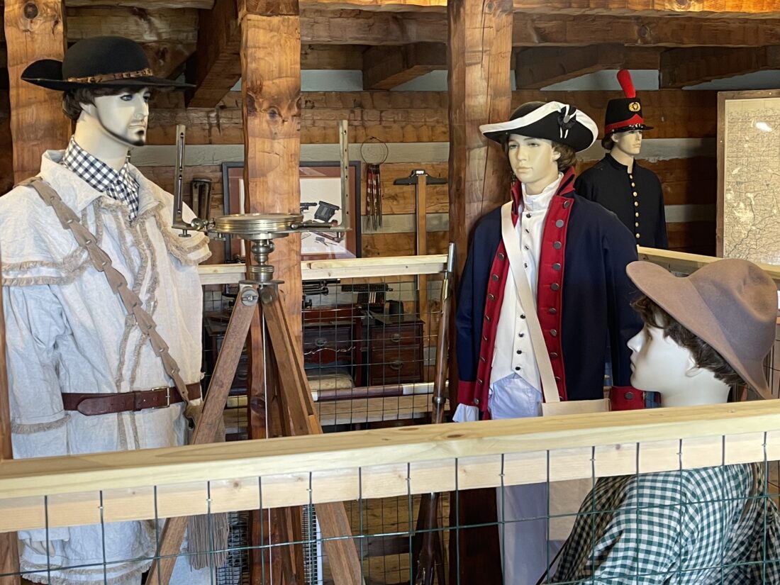
This display inside the Mike Besch Museum of Surveying at Historic Fort Steuben depicts what land work looked like in the Northwest Territory — surveyors took their measurements while being protected by a soldier from the First American Regiment. (Photo by Ross Gallabrese)
James Simpson (Maryland)
Dr. Robert Johnston (Georgia)
Edward Dowse (New Hampshire)
Captain Alexander Parker (Commonwealth of Virginia)
***
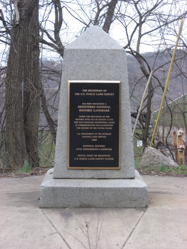
A small obelisk commemorates the Point of Beginning for the historic survey of the Northwest territory. It sits along Ohio State Route 39 near the Pennsylvania border. ELCPR has plans to improve and develop the area. (Submitted photo)
Editor’s note: In the years following the Revolutionary War, the United States stood as an unfinished nation. Victory had secured independence, formalized by the Treaty of Paris, but it had not secured stability. The young republic was burdened by war debt, constrained under the Articles of Confederation, and lacking many of the basic tools of governance — including the ability to tax or maintain a standing army. What it did possess, however, were vast stretches of land. To the west lay the Northwest Territory — a sprawling, largely unmapped expanse that would, in time, give rise to new states and new opportunities. But before expansion could be realized, the land itself had to be understood. That work began in earnest in 1785, when the new government turned to surveyor Thomas Hutchins to impose order on the frontier. He was tasked with creating a system that would allow land to be sold, debts to be repaid, and a young nation to begin standing on its own. That work began in what today is eastern Ohio, at the present-day city of East Liverpool, where a single point on the map helped shape the path of a nation.
***
STEUBENVILLE, OHIO — With the Revolutionary War at its end and the United States holding large parcels of land granted by the Treaty of Paris, the late 1700s were the perfect time for the country to expand to the west.
Before that could happen, though, the new nation needed to survey that land. And for that to happen, it had to select a place where Thomas Hutchins, the first chief geographer of the United States, could begin his work.
The location chosen was where the states of then-Virginia (current day West Virginia) and Pennsylvania and what would become the state of Ohio met. It was the point of beginning, the place where the survey of the Seven Ranges of the Northwest Territory would start.
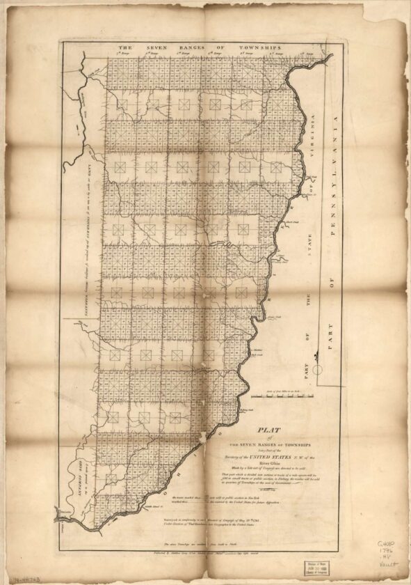
This 1796 map from Thomas Hutchins and on file at the Library of Congress shows the original Seven Ranges survey done to map the western front. The map shows, at the printed right edge, the state of Pennsylvania, with what was then Virginia (present day West Virginia) and then, in the shaded area at left, what would become Ohio.
The actual spot now sits under the Ohio River, but the act of Hutchins of placing that point on Sept. 30, 1785, is memorialized on a marker that sits along the riverbank in East Liverpool, Ohio. From there, the survey was able to begin, and it changed the look of the new nation — and also the way land would be mapped and measured.
“Hutchins comes out and draws the first line — they call it the geographer’s line. That’s a line that is 42 miles long, and it’s going to start at the point of beginning,” said Paul Zuros, executive director of the Historic Fort Steuben in nearby Steubenville, Ohio. “He’s going to start there, and it’s going to be the top of the Seven Ranges.”
Hutchins and his team were using a new technique to measure the land, starting with that fixed point, added Zuros. Each of the Seven Ranges would be broken into townships along a grid system. Each of the 6-square-mile townships would be divided into 36 sections of 1 square mile each.
“They are creating this plan, and there also are four sections inside of the township that were reserved for schools, reserved for township government and for churches,” Zuros added. “Then they reserved some places for the federal government to retain property in each of the townships.”
The Northwest Territory was massive, as there were five states created from it — Ohio, Indiana, Illinois, Michigan and Wisconsin — as well as a portion of Minnesota.
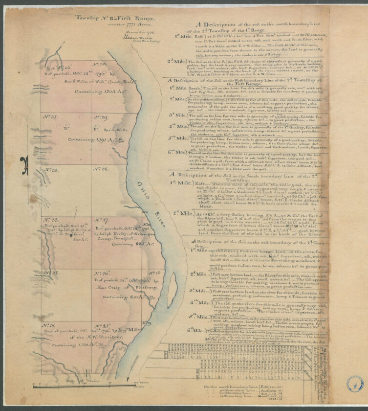
Surveyor Absalom Martin’s 1786 notes, on file at the U.S. National Archives, surveying Range I, Twp. 2 (7771 acres) of the Old Seven Ranges.
Selling off all that land was actually an act of necessity for the government — at the time, post-war, it was completely broke.
“They can’t afford to pay off their debts,” Zuros said. “They can’t afford to pay the soldiers, the veterans of the Revolutionary War. What they decided to do was to go into the Northwest Territory — all of this land that they received from the Treaty of Paris, which ended the war — and measure it out.”
At the time, Zuros said, the new nation was still operating under the Articles of Confederation, which did not give the federal government the authority to tax the states, and they could not have a standing army.
“What they could do was survey land, so that’s what they did,” Zuros added.
There were some issues along the way. Each of the original 13 states was supposed to send a representative to participate in the survey, to ensure everyone had a hand in the process. Some did not, Zuros said.
“So, they started the survey in 1785, and it turns out it’s very dangerous out here,” Zuros said of the unchartered region. “There are concerns with the Native American tribes. There were a series of treaties signed between the tribes and the government. There were a number of them, but all of the tribes were not on board with the treaties.”
Faced with the threat of violence, the surveyors returned to Fort McIntosh in Beaver, Pa., and told the commanders they would not go back into the field unless they had a military escort.
“The following year, 1786, they sent the First American Regiment with the surveyors to protect them out here in the west while they did the mapping of the Seven Ranges,” Zuros said. “It’s a total of about one-fifth of the Army at that point in time.”
With the survey under way, it was decided that a winter quarters was needed, and that led to the construction of Fort Steuben, which was named after Baron Friedrich von Steuben, George Washington’s great drillmaster. The reconstructed fort today is the centerpiece of a park that stretches along Third Street between Market and Adams streets in downtown Steubenville, just feet from the Ohio River.
Construction on the original fort was finished in February 1787 and the fort was abandoned in May, when the surveyors were ready to move on, Zuros explained. It remains the nation’s only fort built solely to protect surveyors.
“The survey of the Northwest Territory is incredibly important,” Zuros said. “This was the first time there would be a standard system of surveying. Out east, in Virginia and the colonies, you had the survey system of metes and bounds. The lines were drawn quite haphazardly, like from the creek line to the old oak tree and from the giant rock to the fence post. It’s confusing, because those things can change.”
The survey and the sale of the land were unique, Zuros said.
“It was one of the first times where people who could afford it, they could buy land from the federal government. You could purchase land here in the west,” Zuros said.
That led to the creation of federal land offices — and the first one in the Northwest Territory was located in Steubenville. Established in 1800 and built in 1801, the structure is part of the Historic Fort Steuben complex.
“It was the jumping off point for people who wanted to purchase land,” Zuros said. “The minimum purchase was 640 acres, and it cost $1 per acre. So, if you had the money, you were set — you could buy a square mile of land.
“They would not accept paper currency,” he added. “You had to pay with gold coins, silver coins, Spanish money or British Pounds — you could not pay with paper. Inflation was huge at that time. They would pay soldiers — the veterans of the American Revolution — and sometimes it was more profitable for those guys to recycle the money, because they could get higher prices for the paper than the denomination that was on the paper.”
There also was no credit at the time — you had to pay off your purchase when it was made.
That system Hutchins used to survey the Seven Ranges, known as the Public Land Surveying System, Zuros said, set up how the nation would grow — in ranges, sections and townships — and it can be seen in use today. When you fly to the western states and look out of the window of the airplane, you see land broken into a grid system, Zuros said, and that all started with Hutchins and the Seven Ranges.
That’s why the Fort Steuben complex was the perfect home for the Mike Besch Museum of Surveying, which is a collaboration of Ann Besch of the surveying and mapping program at the University of Akron, the Ohio Society of Professional Surveyors and Historic Fort Steuben.
“This area, the land office here, was like the Ellis Island of the west,” Zuros said. “People were coming in here looking for a new life. They had the money at this point, and they were buying this land here to set up their homesteads.”
***
How interesting! In our next installment we will head along the Ohio River to Marietta, Ohio, and explore the first permanent settlement in the Northwest Territory. Marietta, founded in 1788, sits at the confluence of the Ohio and Muskingum rivers. This new settlement truly marked the beginning of westward expansion for the growing nation.
Local News
Westward: Seven Ranges survey changed the country
The original surveyors that joined with Thomas Hutchins in mapping the Seven Ranges. Brev. Brigadier General ...

New clinic makes local healthcare more accessible
Hancock County library levy set to go before voters
A long-running levy in support of Hancock County’s three public libraries is set to appear on the May 12 primary ...

SCPD accepts $5,000 donation from Tri-State Ford

CAA Health Centers marking Women’s Health Month
Election chief hopefuls disagree on drop boxes
Ohio Treasurer Robert Sprague, who is running in the Republican primary for secretary of state, said he wants to ...